Geospatial intelligence
Get the right service to the right people.
Geocoding, cluster analysis, and last-mile optimization for public health, government, NGOs, and logistics — turning location data into equitable, efficient reach.
Clean coordinates from messy address data.
We resolve raw address lists — clients, patients, households, or sites — to high-confidence lat/long with batch geocoding, de-duplication, and rooftop-vs-centroid validation. The foundation every spatial decision rests on.
- Batch & streaming geocoding pipelines
- Address standardization + confidence scoring
- Self-hosted, privacy-safe (PHIPA / GDPR) — data never leaves your environment
See where need actually concentrates.
Density clustering turns thousands of points into territories, catchments, and service zones — so you site clinics, place outreach teams, and allocate resources against real geography and real need, not guesses.
- DBSCAN & hexbin demand/need surfaces
- Catchment & territory balancing, facility siting
- Equity analysis — need-based, not geography-based, zoning
Routes & schedules that respect time, skills & capacity.
We model your vehicles, visits, and constraints — time windows, skills, acuity, capacity — then solve with GPU-accelerated optimization to cut travel, overtime, and missed visits. Parcels, home-care nurses, or mobile clinics, same engine.
- VRPTW / HHCRSP routing & scheduling
- What-if scenario simulation & trade-offs
- Self-hosted solver — no data leaves your environment
Dashboards we've shipped.
Interactive deliverables from real engagements — geocoding, demand clustering, and last-mile coordination. Click any tile to explore the live dashboard. All data shown is anonymized / synthetic — client locations are shifted and re-labelled, so nothing identifiable leaves the room.
Coordination Dividend
Models the "coordination dividend" — how many front-line workers are freed up when multi-agency visits to the same building are pooled instead of dispatched separately. Anonymized demo data.
- Multi-agency visit-pooling model
- Worker continuity & dispatch view
- Buildings ranked by dividend
Coordination Explorer
A what-if explorer for multi-agency home-care coordination — how visits, hours, and acuity redistribute across providers when territories are re-balanced.
- Scenario simulation & trade-off views
- Agency / ward / building-type breakdowns
- Coordination-gap surfacing
 Routing & scheduling
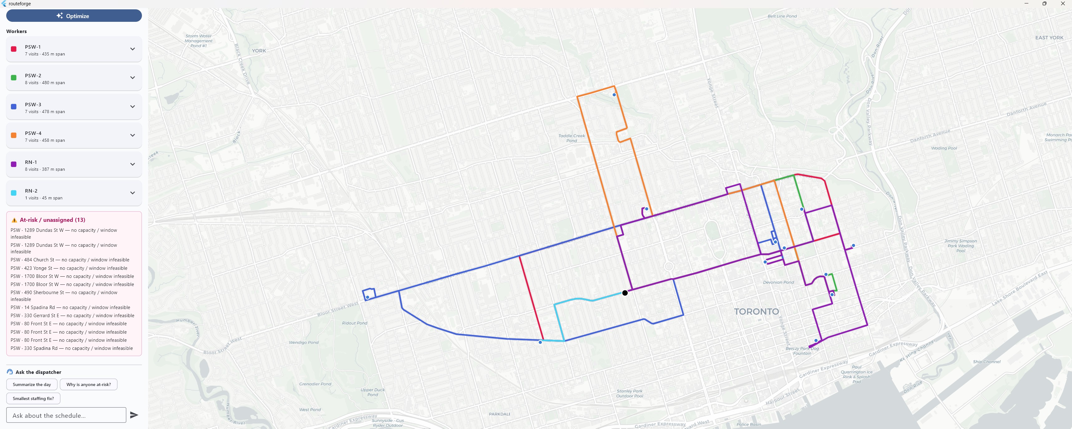
RouteForge Simulator
GPU-accelerated VRPTW / HHCRSP routing engine with a live scenario UI — solves vehicle routes and nurse schedules against time windows, skills, and capacity. Includes a built-in dispatcher assistant.
- cuOpt-backed solver, self-hosted
- Drag-to-edit constraints, instant re-solve
- Travel / overtime / missed-visit metrics
Heatwave Risk Dashboard
A live heat-warning & vulnerability dashboard — pairs real-time ECCC heat criteria with NORC / older-adult risk surfaces to direct cooling-centre outreach where it matters most.
- Region-specific heat-warning thresholds
- Vulnerability-weighted risk hotspots
- Deployed on Cloudflare Workers
Pick a scope.
From a one-off geocoding cleanup to an embedded optimization partner.
Map Sprint
A focused 1-week diagnostic.
- Geocode + clean your address data
- Demand cluster map
- Savings opportunity report
Optimization Build
End-to-end routing model.
- Full VRPTW/HHCRSP model
- What-if scenario dashboard
- Self-hosted deployment
Embedded Partner
Ongoing optimization retainer.
- Monthly scenario reviews
- Solver tuning & support
- Team enablement
Let's talk
Model your service network.
Send your address list and constraints — get a feasibility & savings estimate back within a week.
A real-time digital twin.
Everything above — geocoded points, need clusters, optimized routes — comes together as a live 3D digital twin of your operation on a true globe, ready for 3D and immersive VR/AR review. Drag to orbit · scroll to zoom.